Case History
Some aspects of the M6.3 April 6 2009, L’Aquila, Italy, earthquake
By Armando L. Simonelli (Università del Sannio, Email: alsimone@unisannio.it)
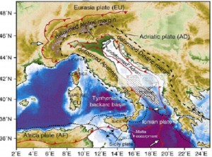
Figure 1. Geodynamic model for the central Mediterrannean (Devoti et al., 2008) and location of L’Aquila earthquake (adapted from [1])
On April 6th 2009, 03:32 local time, a strong earthquake hit the town of L’Aquila on the Appenninic chain in central Italy (Fig. 1). The sequence started in December 2008 as a series of small earthquakes and reached its climax in April 2009. Three events above M5 took place on April 6, 7 and 9 which devastated the town and its vicinity. An international team sponsored by GEER project and several Italian-only teams sponsored by AGI and ReLUIS project performed reconnaissance of the event. Most of this note is extracted from their reports ([1] and [2]).
L’Aquila area
AQV – pga=0,68 g
The city of L’Aquila and several small towns along the Aterno river valley suffered severe damage. About 300 people died as a result of the earthquake and several tens of thousands were left homeless. Most of the deaths took place in vulnerable masonry houses which were subjected to unusually strong motions – mainly due to proximity to the fault. In the days following the earthquake, a large number of researchers visited the area. A preliminary report on the main features of the recorded ground motions was compiled by a group of Italian investigators [2] under the umbrella of Italian Geotechnical Association (AGI) and the National Network of Earthquake Engineering Laboratories (ReLUIS) project. A detailed report on seismological and geotechnical aspects of the earthquake was produced by an international group of researchers [1] sponsored by the Geo-Engineering for Extreme Events Reconnaissance (GEER) project. The brief note at hand refers to geotechnical damage and is based on the above works. Information about structural damage is available at ReLUIS web site (www.reluis.it) and elsewhere.
According to Italian Institute of Geophysics and Volcanology (INGV), the main shock took place along a normal fault oriented NW-SE, with local magnitude ML = 5.8 and moment magnitude MW = 6.3. The hypocentral depth was estimated at approximately 10 km. Four accelerometric stations (AQV, AQA, AQG, AQK) were located within the surface projection of the fault and recorded peak values ranging from 0.4 to 0.6g. Peak computed ground velocities were estimated at around 35 cm/s. All stations were located in the Aterno river valley, NW of L’Aquila city and in the city itself (Fig. 2).
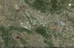
Figure 2. RAN accelerometric stations in the meizoseismal area around the city of L’Aquila (image from GoogleEarth)
Download ISSMGE Bulletin – Volume 3 Issue 3 (pp. 21-24)
![]() PDF format
PDF format


