March 2017: Climate Change, Environmental Geotechnics and Geo-hazards
Edited by
Kazuya Yasuhara, Farrokh Nadim and Dennes Bergado

Prof. Kazuya Yasuhara
Kazuya Yasuhara is Professor Emeritus of Ibaraki University in Japan; His academic career started in Kyushu University where he was from 1968 to 1978, earning a Doctoral Degree as well. He was then a Professor at Ibaraki University from 1990 to 2007. Prof Yasuhara was the International Project Coordinator at the Institute of Global Change Adaptation Science from 2010 to 2015. He was also a Review Editor for IPCC AR 5 from 2010 to 2014. Since 2015, Prof. Yasuhara is a Specially appointed researcher at Ibaraki University.
Prof. Yasuhara was at University of Illinois Urbana- Champaign in Illinois, USA from 1979-1981 and was a Post Doctorate Research Fellow at the Norwegian Geotechnical Institute from 1986 to 1987. Prof. Yasuhara was the recipient of several prestigious awards: ASCE Best Paper Award in 1999; JGS Award for Meritorious Service in 1999; Groundwater Science and Technology Award (IAHR) in 2000; JGS Award for the Best Research Achievement in 2004; Best Paper Award from Japan Chapter of International Geosynthetics Society in 2006; and JGS Meritorious Research Award for Ground Environment in 2008. His current research interest is in Climate change-induced compound geo-disasters in Asia-Pacific regions and their adaptation countermeasures against earthquake-induced settlements of infrastructures. Prof. Yasuhara is the author of a very large number of publications in this field and others in Geotechnics.

Dr. Dr Farrokh Nadim
Dr. Dr Farrokh Nadim is the director of the Centre of Excellence, the “International Centre for Geohazards” (ICG), at the Norwegian Geotechnical Institute (NGI). He has a BSc in structural engineering from Sharif University of Technology in Iran, and MSc and ScD degrees in civil engineering from Massachusetts Institute of Technology (MIT). Dr Nadim came to NGI in 1982 on a post-doctoral fellowship and joined NGI as a fulltime employee in 1984. His major fields of work are related to landslides and geohazards, risk and reliability analysis, geotechnical earthquake engineering, behaviour of geotechnical structures under cyclic and dynamic loading, and offshore foundation engineering. He is author or co-author of over 80 scientific publications, and Chair of Technical Committee 32 of ISSMGE: “Engineering practice of risk assessment and management”. Since 2003 Dr Nadim has been an adjunct professor at both the Norwegian University of Science and Technology (NTNU) and University of Oslo (UiO).

Prof. Dennes Bergado
Prof. Bergado (Dennes) was in the Geotechnical Engineering batch that graduated from AIT in 1976. After working for a while in Philippines, Prof. Bergado studied at Utah State University in USA on a Full Bright Scholarship and worked with Prof. Loren Anderson. Prof. Bergado joined AIT as an Assistant Professor in 1982. At AIT in the early years Prof. Bergado was involved with many major Sponsored Research Projects including the USAID Funded Welded Wire Mechanical Stabilized Earth and Geosynthetics in Embankments on Soft Clays. Prof. Bergado was also deeply involved with the PVD Soft Ground Improvement Project at the Second Bangkok (Suvarnabhumi) Airport Site with the Airport Authority of Thailand. The Doctoral Students of Prof. Bergado were: Prof. Shivashankar, Prof. Chai, Dr. Long, Dr Panich, Dr Lorenzo, Dr Sompote, Dr Lai, Dr Abuel-Naga, Dr Chairat, Dr. Pittaya, Dr Jaturonk, and Dr Tawatchai to name a few. He successfully supervised a total of 17 doctor and 160 master graduates. Prof. Bergado wrote 2 books in soil/ground improvement, edited 22 conference proceedings with more than 140 journal and 280 conference papers. Prof. Bergado also edited the Volume on Geotechnical Engineering in SE Asia for the Golden Jubilee Conference at San Francisco in 1985. Prof. Bergado was associated with the Southeast Asian Geotechnical Society from the time he joined AIT, earlier as Editor of the Journal (1996-2000) and later became the Secretary General of SEAGS (2001-2012). He also initiated the Asian Center for Soil Improvement and Geosynthetics (ACSIG) and founded the International Geosynthetics Society (IGS)-Thailand Chapter. Currently, he is serving his second term as elected member of the IGS International Council. Prof. Bergado spent his Sabbatical at Saga University.
PREFACE
There are fourteen papers in this Issue edited by Yasuhara, Nadim & Bergado. The first paper is by Yasuhara et al on Geo-disasters in Japan in the Context of Climate Change. The authors say: Japan is an area affected strongly by land surface upheaval and by climate change instability. Background evidence of increasing and magnifying geo-disasters includes the following: (i) frequent and extremely severe torrential rainfall; (ii) high and increasing frequency of strong earthquakes (5+ and 6- as the Japan Meteorological Agency seismic intensity scale); and (iii) typhoons with magnified damage effects. Based on a review of that information stated above, an attempt has been made to overview the present situation and future trends of geo-disasters in the context of climate change and to present possible adaptive measures against disasters. Particularly, emphasis is assigned to the importance of the combined effects of plural events, which increases the probability of extreme events, sometimes triggering devastating consequences. Adaptive measures against climate change-associated geo-disasters are presented by classification into software and hardware. Special emphasis is devoted to the availability of information and communication technology (ICT) and information, communication and robot technology (ICRT) involving devices such as IC-sensors and un-crewed vehicles (UAV, drones), which are useful in early warning systems and in simple monitoring systems.
The second paper is by Do Minh Duc et al on climate change impacts in a large-scale erosion coast of Hai Hau district, Vietnam and the adaptation. It seems among the effects of global warming, sea level rise (SLR) and severe typhoons pose the greatest threat to the stability of human settlements along coastlines. Therefore, countermeasures must be developed to mitigate the influences of strong typhoons and persistent SLR for coastal protection. This study assesses climate change impacts on coastal erosion, especially in two projected SLR scenarios of RCP2.6 and RCP8.5. The results show that SLR and severe typhoons lead to the increase of coastal erosion, beach lowering and scour. Moreover, as in projected SLR scenarios, average waves in high tide can cause severe soil erosion at inner slopes and lead to dyke failure by 2060. The paper highlights the need for additional geotechnical engineering measures to protect the coast of Hai Hau district against SLR and severe typhoons. Among the alternatives available for countering these threats, applying soil stabilization and soil improvement combined with geosynthetics are promising strategies for coastal structures. Hybrid structures can be used with earth reinforcement and soil improvement. Additionally, the paper emphasizes the importance of multiple protective adaptations, including geosynthetics and ecological engineering measures against climate change-induced severe erosion on the coast of Hai Hau district.
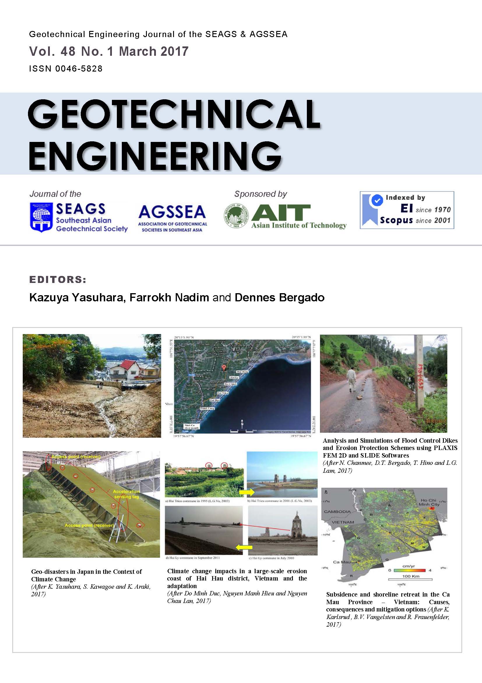
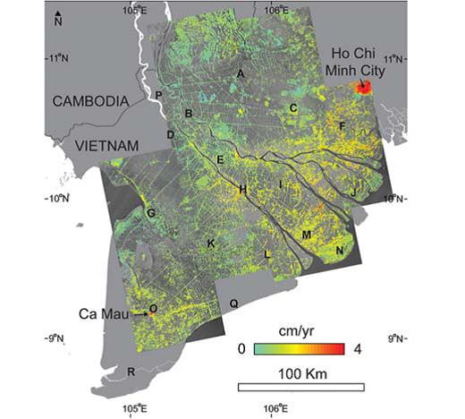
Karsrud et al in the third paper described subsidence and shoreline retreat in the Ca Mau Province – Vietnam: Causes, consequences and mitigation options: The authors say in the past decades, the Ca Mau province located at the southern end of Vietnam, has experienced significant land-loss. Satellite data suggest that a loss of land, or a retreat of the shoreline, ranging from about 100 m to 1.4 km have occurred over the past 20 years or so. In addition to the retreating coastline, the Ca Mau coastline has experienced loss of mangrove forests and salt-water intrusion into canals and rivers in the region. A study undertaken in collaboration between Vietnamese and Norwegian institutions has tentatively concluded that the main cause of the land-loss is subsidence of the ground surface as a result of ongoing groundwater pumping. The experienced land-loss may be further enhanced by a climate change related sea-level rise. Large parts of the land area in Ca Mau lie less than 1.5 m above sea-level. The subsidence settlements may already have reached 40 to 80 cm in some places, and the present subsidence rates may correspond to 2-4 cm/year. Recent satellite based data using In SAR technology (Interferometry Synthetic Aperture Radar) confirm that significant subsidence is on-going in all provinces in Vietnam from Ho Chi Minh City and southwards. If no actions are taken soon, the implication will be that these provinces are lost to the sea within a time frame of a few decades.
The only realistic way to prevent such subsidence settlements is to greatly reduce groundwater pumping in the area, and replace it with water from other sources. Also in light predicted climate-change related sea-level rise, some physical barriers may also be required to protect the region against flooding. It is recommended to immediately initiate an observational program and supplementary analyses to verify the present and future subsidence of the ground surface in Ca Mau. This is to ensure that remedial actions are planned for and implemented before it is too late.
In their paper (fourth one) Yahaya et al present rainfall erosivity variability for Penang Island in Malaysia. Rainfall erosivity considers the rainfall amount and its intensity. This is an important parameter for soil erosion risk assessment under future land use and climate change. Comparisons of all climatic parameters show that rainfall is directly involved in the loss of soil quality during torrential rain. The effect of rainfall erosivity in Northern part of Malaysia was considered for two stations, Bukit Berapit and Air Itam. Monthly as well as annual rainfall was obtained from the Department of Drainage and Irrigation, Malaysia for thirty years (1983-2012). Trends analysis of the rainfall data were obtained for 30 years that shows trends for mean annual rainfall. This was conducted using Mann-Kendall trend analysis and Sen’s slope tests. Trend analysis shows that there is negative significant difference in mean annual rainfall for the studied period for Air Itam. The Fournier indexes were used to determine the effect of extreme rainfall events towards soil erosivity. Bukit Berapit recorded 3.33% cases of severe impact using Fournier index and 13.33% cases of high impact using modified Fournier index. The result shows that there is a relationship between rainfall trends and soil erosivity.
The fifth paper is on the influence of increased precipitation on the transient seepage through levees during flood events. This paper is by Scheurmann et al. The transient seepage through levees during a flood event depends on several factors, such as the initial water content condition within the levee as a result of former flood and precipitation events which is frequently neglected. Results of experimental and numerical investigations are presented which show the importance of the initial water content distribution on the resulting transient seepage. Analytical methods for calculating the transient seepage through levees are introduced. The modified method after Brauns (1999) allows for the determination of the seepage through levees under consideration of partly saturated conditions. The initial conditions for the transient seepage can be chosen based on simple considerations related to the field capacity or the effective infiltration of water due to precipitation.
Hazarika in his paper sixth in the series discuss the use of low carbon and low cost (LC2) Materials in climate change adaptation measures. Material recycling of waste tires, which reduces the release of greenhouse gases, for protecting coastal structures from potential natural hazards is proposed here. A new technique using waste tires behind sea walls to protect them from the damage due to impact force of tsunami is described. Cultivation of suitable plants inside the tires was proposed and field tests on planting trees that can grow in saline soil conditions were performed to see whether tire structures can preserve the greenery of the area. A physical model for tsunami impact force simulation was also developed to evaluate the reduction effect of tsunami impact force by the tire structures. Results of this research, if implemented, is not only expected to contribute towards economic countermeasures against natural hazards, but also will go a long way towards providing a sustainable solution for infrastructure development in the future.
Lee et al are the authors of the seventh paper on performance monitoring of bridge foundations under multi-hazards
In an effort to proactively monitoring the safety of bridge foundations so as to probe the possible performance of bridge foundation during natural hazards such as floods, debris flows, rainstorms, and typhoons, an intelligent monitoring system was developed by the authors and had applied to several bridges. In this paper, theoretical background and development will be firstly described. Two case histories will then be presented to describe performance of bridge foundation during natural hazards. Such information will be also further discussed by integrating environment factors such as rainfall amount and flow velocity. Research progress presented in this paper is hoped to be helpful in understanding performance of bridge foundation during hazards so as to provide insights of pre-warning of bridge safety.
The eighth paper by Chanmee et al is titled analysis and simulations of flood control dikes and erosion protection schemes using PLAXIS FEM 2D and SLIDE computer softwares. In 2011, Thailand has suffered from devastating flooding due to climate change. During this time, 2 typhoons from the Pacific area went straight across Vietnam to Northern Laos and Northern Thailand instead of the usual path to Taiwan and Japan. Subsequently, huge flooding damaged many infrastructures and overtopped flood protection dikes of many industrial estates and educational institutions in the Central Plain of Thailand such as at Hi-Tech Industrial Estate, Bang Pa-In Industrial Estate, Navanakorn Industrial Estate and Asian Institute of Technology. The same phenomenon also occurred in Laos PDR which caused unusually heavy rains and widespread river flooding in 2011.
Consequently, slope failures occurred along National Road 1B (NR 1B) in Pongsaly Province in Northern Laos due to undercutting erosions at the lower slopes by the adjacent flooded river. To evaluate the stability of these protection structures, finite element and limit equilibrium methods were utilized. PLAXIS 2D software was used to analyze the slope stability of improved flood protection dikes and erosion control schemes at low and high water levels incorporating the various supporting and reinforcing materials such as geosynthetics, concrete sheet pile and concrete slab. Moreover, the PLAXIS 2D software was also utilized to predict the vertical deformations (settlements) of improved flood protection dikes in cases of additional embankment height and at different cases of flood water levels. In addition, the SLIDE software was
used to predict the value of the factor of safety by using limit equilibrium method for the improved flood protection dikes and erosion control schemes.
In the subsequent paper nine in the series Araki et al deal with arresting rainfall-induced red soil runoff in a farmland by inhibitory adaptation measures. Climate change-induced red soil erosion in Okinawa of Japan has become widely recognized due to the increased frequencies of heavy rainfall. Approximately 85% of runoff from farmland is accounted as a source of the red soil erosion. In this study, field experimental plots were conducted in Ginoza village in Okinawa to investigate the effectiveness of potential adaptation measures in arresting the red soil erosion. A physical model for estimating a sediment volume of soil erosion was derived based on grain size distribution. The maximum particle sizes were derived as a function of rainfall intensity, initial soil conditions and strength parameters of the surface soil. The measured maximum particle sizes of the discharged red soil were agreed well with the model results and could offer the basis for determining an appropriate method of adaptation based on geotechnical aspect.
Umino et al in the tenth paper deal with iron and steel slag properties and mechanisms for carbon dioxide fixation in a low-carbon society. The paper presents carbon dioxide (CO2) fixation properties of an iron and steel slag containing calcium, in order to contribute to a geotechnical application for the formation of a sound material-cycle society and a low-carbon society. To investigate the properties of CO2 fixation, CO2 fixation tests with constant flow were conducted. Results show that when the CO2 concentration 4500 L- CO2/L was flowed in a specimen by 0.05 L/min, for a non-aged steelmaking slag, the amount of CO2 fixed was the maximum: 0.04 g- CO2/g-slag. The amount of CO2 fixed in the steelmaking slag resulted from about 20% of soluble calcium in the chemical reaction. Therefore, it is possible that the quantity of CO2 fixation can be evaluated from the viewpoint of the mechanism of CO2 fixation using the quantity of water soluble calcium.
Kusakabe et al in the eleventh paper deal with the development of gross national safety index for natural disasters. After the Great East Japan Earthquake on March 11, 2011, it appeared that Japan was extremely vulnerable to natural disasters and lack of adequate social systems for mitigating natural disasters. The authors advocated a need for the development of safety index systems for natural disasters for policy makers and decision makers to prioritize mitigation measures to be implemented. The World Conference on Disaster Reduction in Kobe in 2005 adopted the Hyogo Framework for Action, which clearly states the urgent need for developing vulnerability index. An extensive literature survey was firstly conducted to find out the State of the Art regarding to the development of systems of indicators of disaster risk and vulnerability at national and sub-national scale. The survey indicates that the system of indicators such as World Risk Index (WRI) is widely accepted. By modifying the WRI index, a new index named GNS (Gross National Safety for natural disasters) was developed in this study. Risk in GNS is defined by Hazard x Exposure x Vulnerability. Five natural events are considered in 2015 version of GNS, including earthquake, tsunami, storm surge, sediment related disaster event, and volcanic activity. An initial calculation was carried out by using various big data available open to public. The results of disaster risk and vulnerability are presented in the prefectural scale in Japan. Our intension is not to provide the ranking of GNS but to offer the policy and decision makers a piece of scientific information for selecting highest priority measures for mitigation in a rational manner. A few commentary remarks are added to include the impact of climate change on natural disasters in the safety index system.
The twelfth paper by Yuan et al. describes the flooding hazards and potential risks due to heavy rain and sea level change in Shanghai, China. Current sea level change is mainly induced by global warming which is believed to increase the sea level if sustained for a sufficiently long period of time. Many coastal cities around the world have suffered adverse effects as a consequence of sea level change. Shanghai is a coastal city which is located on the estuary of the Yangtze River with an elevation ranging from 3 to 4 m. Its geological and climatic conditions make the city sensitive to flooding risk caused by heavy rain and sea level change. This paper analyses the recent sea level change and heavy rainfall in Shanghai. Regional rates of sea level change can be divided into i) the rate of eustatic sea level change; ii) tectonic movement of the continent; and iii) land subsidence in Shanghai. A correlation analysis shows that the number of local torrential rains and short duration torrential rains correlates with sea level change. Incidents including pluvial flooding, sea water intrusion and potential damage to coastal structures will be more serious if the rate of sea level change continues to rise. To protect the environment and to control economic losses, more countermeasures should be established to prevent the potential hazards.
The thirteenth paper by Soralump and Chaithong is on the modeling impact of future climate on stability of slope based on general circulation model. Slope failures are one of geo-hazard which are one of the most dangerous and occur very often. Climate is an important role in stability of slope. In many cases rainfalls induce slope instability and lead to slope failure or landslide whereas evaporation might stabilize slope. Climate change due to greenhouse effect and global warming might affect precipitation and evaporation patterns in the future and influence future slope failure. Therefore, the paper proposes a method for assessment impact of climate change on slope failure occurrences based on general circulation model (GCM). Methodology combines between climate scenarios as a result of general circulation model and modified critical antecedent precipitation index model. GCM results are downscaled with dynamical-statistical technique to derive local climate. Analysis found that trends of susceptibility of soil instability vary and depend on climate in each year period.
The fourteenth paper by Ghosh and Pal describes the geotechnical measures for Uttarakhand Flash Flood in 2013 in India. In many “Run of the River” hydro-electric projects in the four main states of northern India have been frequented by “Cloud Burst” induced flash flood since 2003, which is primarily attributed to climate variability and land use pattern changes. Given the ageing population of vulnerable constructions along the hilly terrains, safety issues require more attention in the form of technical auditing cum inspections, routine monitoring, emergency drills, surveillance systems, and regularly updated emergency action plans. In addition to these accelerated events of “cloud burst” induced flash flood in the hilly region has opened up Dam safety issues, which are debated in the court of law for which geo-professional intervention have to be looked into. The climatic and other geo-morphological changes that might have caused Uttarakhand Flash Flood in 2013 are explained. Damages to the geotechnical structures in the form of excessive erosion, landslides, siltation of catchment area of several Dams in Uttarakhand state of India are described with some illustrations of landslide mitigation by indigenous bio-engineering solution as one the means of rehabilitation measures.
Editors:
Kazuya Yasuhara,
Farrokh Nadim
and Dennes Bergado
ACKNOWLEDGEMENT
Fourteen papers on Climate Change & Geotechnics are contained in this Issue. No doubt the material contained herein would be most valuable to our profession. The editors have adequately described the contributions in the preface. They are to be congratulated for these contributions.
Dr. Teik Aun Ooi
Prof. San Shyan Lin
Prof. Kwet Yew Yong
Dr. Noppadol Phienwej
Prof. A. S. Balasubramaniam
Contents
Geo-disasters in Japan in the Context of Climate Change
By K. Yasuhara, S. Kawagoe and K. Araki
Climate change impacts in a large-scale erosion coast of Hai Hau district, Vietnam and the adaptation
By Do Minh Duc, Nguyen Manh Hieu and Nguyen Chau Lan
Subsidence and shoreline retreat in the Ca Mau Province – Vietnam: Causes, consequences and mitigation options
By K. Karlsrud, B.V. Vangelsten and R. Frauenfelder
Rainfall Erosivity Variability for Penang Island
By A. S. Yahaya, F. Ahmad , Z.A Mohtar and S. Suri
Influence of increased precipitation on the transient seepage through levees during flood events
By A. Scheuermann, J. Brauns and A. Bieberstein
Use of Low Carbon and Low Cost (LC2) Materials in Climate Change Adaptation Measures
By H. Hazarika
Performance Monitoring of Bridge Foundations under Multi-hazards
By W. F. Lee, C. I. Yen and C. K. Huang
Analysis and Simulations of Flood Control Dikes and Erosion Protection Schemes using PLAXIS FEM 2D and SLIDE Softwares
By N. Chanmee, D.T. Bergado, T. Hino and L.G. Lam
Arresting rainfall-induced red soil run off in a farmland by inhibitory adaptation measures
By K. Araki, N. Yasufuku, K. Iwami, K. Okumura, K. Omine and K. Vilayvong
Iron and Steel Slag Properties and Mechanisms for Carbon Dioxide Fixation in a Low- carbon Society
By M. Umino, H. Komine, S. Murakami, K. Yasuhara, K. Setoi and Y. Watanabe
Development of Gross National Safety Index for Natural Disasters
By O. Kusakabe, M. Kikumoto, K. Shimono, K. Itoh, H. Inagaki, S. Ohsato and K. Watanabe
Flooding Hazards and Potential Risks due to Heavy Rain and Sea Level Change in Shanghai, China
By Y. Yuan, Y. S. Xu and S.L., Shen
Modeling impact of future climate on stability of slope based on general circulation model
By S. Soralump and T. Chaithong
Geotechnical Measures for Uttarakhand Flash Flood-2013, India
By C. Ghosh and I. Pal